USDOT Names 2 New Marine Highway Systems

[Stay on top of transportation news: Get TTNews in your inbox.]
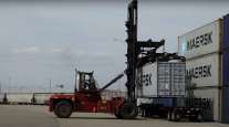
Two new marine highway systems have added 250 miles to the Ohio River system and 6,500 miles of Alaskan waterways to the national transportation system to improve freight shipments, U.S. Transportation Secretary Pete Buttigieg announced.
“America’s marine highways are vital links in our supply chains, helping to move goods quickly, cleanly and efficiently,” Buttigieg announced Aug. 16. “By expanding our marine highway system, we can strengthen our supply chains, improve port operations, and help keep goods affordable for American families.”
DOT defines a marine highway route as a waterway in the United States or its territories that is navigable and able to be used for transporting freight.
“Our nation’s marine highway routes are navigable waterways capable of moving significant quantities of freight at lower costs than other means of transportation,” said Ann Phillips, administrator of the Maritime Administration.
There are now 31 designated marine highways; the federal government started the Marine Highway Program in 2010. Although the federal government doesn’t directly operate marine highway services, it provides grants to develop and broaden marine highway service operations to better integrate waterborne cargo into the U.S. multimodal surface transportation system.
The federal government has awarded $91.6 million in competitive grants to eligible organizations for marine highway services to support developing and expanding marine highways, vessels and land-side port/infrastructure that are important to creating supply chain resilience, Phillips noted earlier this year.
We added the newest waterway to the U.S. Marine Highway system: M-11 in Alaska. Marine Highways sustain jobs, bolster our supply chains, and are a key economic driver, @SecretaryPete joined Sen. @LisaMurkowski to announce this news. pic.twitter.com/mzAXEcXfXb — TransportationGov (@USDOT) August 18, 2023
In March, she announced the availability of $12.4 million in grants for fiscal year 2023 funds through the Marine Highway Program.
The new Alaskan route (called the M-11) will be overseen by the Alaska Department of Transportation and Public Facilities. The new waterway includes ports along the coast and rivers in southwestern and northern Alaska from the Aleutian Islands to the Canadian border. DOT notes that many local communities depend on a system of ports, rivers, barge landings and airports to transport goods and people. The new M-11 route is meant to give businesses and area residents more waterway transportation options.
Pennsylvania and West Virginia residents will benefit from the new M-79 Marine Highway Route, co-sponsored by the Port of Pittsburgh Commission and the Morgantown Monongalia Metropolitan Planning Organization (MMMPO) in West Virginia. The new marine highway designation now extends the reach of the Ohio River system by nearly 250 miles, adding the easternmost tributary rivers.
Want more news? Listen to today's daily briefing above or go here for more info
“Local business interests in the region, including river terminals and operators, are looking to waterborne transportation as a reliable and cost-effective alternative to other forms of surface transportation. The M-79 will serve as an incentive for increased operations, infrastructure investments and freight movement, especially for new commodities that will move on the water in the future,” DOT stated.
According to the MMMPO’s May 2022 transportation plan, the towns of Monongalia and Morgantown are historically tied to the Monongahela River that links the area to Pittsburgh. Although the river used to provide the most efficient cargo transportation to the Ohio River Valley and was dominated by lumber and coal shipments, today it mostly moves coal and limestone out of West Virginia.