Ida Aims Hurricane Strike at Louisiana on Katrina’s Anniversary

[Stay on top of transportation news: Get TTNews in your inbox.]
Hurricane Ida is taking aim on New Orleans on the 16th anniversary of Katrina, one of the most devastating natural disasters in U.S. history.
Ida’s maximum sustained winds accelerated to 75 mph, tipping it into hurricane status, the National Hurricane Center said at 1:15 p.m. EDT on Aug. 27. The storm’s top winds could reach 120 mph as it comes ashore on the night of Aug. 29 as a powerful Category 3 hurricane, according to the center’s most recent forecast. New Orleans and other settlements along the Gulf Coast have already started telling some residents to flee and hospitals in the Big Easy are sending home patients and planning to lock down before landfall.
“It looks pretty bad,” said Don Keeney, a meteorologist with commercial forecaster Maxar. “The official track is just west of New Orleans, which would be bad for New Orleans.”
Louisiana Children’s Medical Center is sending home some patients and will put its six New Orleans-area hospitals into lockdown the morning of Aug. 29. On its current track, the storm could cause as much as $25 billion in damage and losses, said Chuck Watson, a disaster modeler with Enki Research. It will be the most powerful storm to hit the U.S. so far this year.
The ninth storm of the 2021 Atlantic hurricane season, Ida’s top winds have increased to 65 mph as it swirls in the Caribbean Sea about 75 miles southeast of the Isle of Youth. It’s forecast to strike Cuba later Aug. 27, reach hurricane strength on Aug. 28, and make U.S. landfall late Aug. 29 or Aug. 30.
Hurricane #Ida Advisory 5A: Ida Makes Landfall as a Hurricane On the Isle of Youth. https://t.co/VqHn0u1vgc — National Hurricane Center (@NHC_Atlantic) August 27, 2021
Oil and gas prices gained as energy companies shuttered facilities and evacuated workers. Aug. 29 will be 16 years to the day since Katrina wreaked havoc on New Orleans as a major hurricane.
“Sunday is the anniversary of Katrina — it seems like a particularly cruel date for a hurricane landfall in Louisiana,” said Ryan Truchelut, president of Weather Tiger.
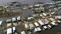
Hurricane watches have been issued from the hamlet of Cameron in southwest Louisiana to the Mississippi-Alabama border. Storm-surge watches have been issued from Sabine Pass in Louisiana to the Alabama-Florida line. Tropical systems in the Northern Hemisphere pack more punch on their east sides, so if Ida strikes west of New Orleans it could push a massive wall of seawater into Lake Pontchartrain and up the Mississippi River. That would test flood-protection systems constructed after Katrina.
Louisiana Gov. John Bel Edwards declared a state of emergency ahead of the storm, according to a Twitter post.
New Orleans, often referred to as NOLA, is below sea level and depends on levees and pumps to keep the ocean and river out. Ida could push ocean levels as high as 11 feet in places as it comes ashore.
“NOLA is always a place that things can go wrong quickly and badly,” said Enki Research’s Watson.
Even if the levee system holds and keeps the surge at bay, New Orleans could face a major flood risk from the rain alone, Truchelut said. The city has had one of its wettest years so far, and with heavy rain expected there could be widespread flooding.
Five storms have already hit the U.S. this year as climate change fuels extreme weather around the globe. Wildfires are threatening Lake Tahoe, Calif., and have forced the Boundary Waters Canoe Area Wilderness in Minnesota to close for the first time since 1976. Blazes are raging across southern Europe; flooding and mudslides killed at least 20 people this week in Venezuela.

How much impact does driver pay have in hiring drivers? And what else can fleets do to recruit and retain quality talent? Hear a snippet from DriverReach founder and CEO Jeremy Reymer, above, and listen to the full program at RoadSigns.TTNews.com.
Tropical systems can bring more rain because with every 1 degree Celsius the world warms the atmosphere can hold 7% more moisture.
Oil explorers are bracing for the storm and have already halted the equivalent of more than 1.2 million barrels of daily crude production. Royal Dutch Shell, BP and others are shutting offshore platforms and evacuating crews.
‘High-Octane Fuel’
Hurricanes thrive on warm water and Ida’s projected track takes it across parts of the Gulf with surface temperatures in the high 80s Fahrenheit. The storm could also sweep over the so-called Loop Current, which has some of the warmest and deepest water in the region. That means it could get even stronger than the current forecast of Category 3.
“All the way to the coastline it has a lot of high-octane fuel,” said Weather Tiger’s Truchelut.
After Ida comes ashore, it could flood cotton, corn, soybean and sugar cane crops, Keeney said. The hurricane center is also tracking two other weather systems: one east of Bermuda has a 50% chance of becoming a storm in the next two days, and another between Africa and the Caribbean has a 60% chance.
Want more news? Listen to today's daily briefing below or go here for more info: