Plan to Enlarge Mobile Ship Channel Raises Environmental Issues
A plan is afoot to widen and deepen the Mobile Ship Channel to allow larger ships carrying more cargo to make their way up Mobile Bay.
The proposed expansion raises several environmental issues that federal documents suggest will be addressed at a later date, once a preferred design for the channel has been selected. A $7.8 million study is underway now to examine the costs, benefits and environmental and economic consequences of enlarging the channel.
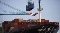
Jimmy Lyons, director of the Alabama State Port Authority, said the expansion of the channel is vital to the future of Mobile as a port. With the widening of the Panama Canal last year, much larger ships — so called Super Post-Panamax ships — are calling on the port. But they cannot make it up Mobile Bay fully loaded because the channel is only 45-foot deep, and so the ships must sail with their holds only partially full.
What's more, these new ships are so wide that two cannot pass through the ship channel at the same time, meaning the channel must be closed to other traffic as one of the giant vessels enters or leaves the port. This means ships are sometimes forced to idle in the Gulf for six or seven hours before they are allowed to begin the ten-hour journey up the bay.
The solution, docks officials say, is enlarging the channel, which would allow the ships to carry a full cargo thanks to increased depth. It would also do away with the one-way traffic problem, and end the prohibition against large ships travelling through the bay at night, thanks to a wider entrance at the mouth of Mobile Bay.
Ultimately, the larger channel would allow many more ships to dock each year, making the port more attractive to shippers. Similar expansions have occurred at several U.S. ports to handle the new generation of larger ships.
"This project is necessary to ensure our ability to competitively serve Alabama business. The Port Authority does not benefit substantially from this project — meaning we are not going to make millions of dollars if this channel is modernized," said Lyons. "It's our shippers, manufacturers and agribusiness stakeholders and associated jobs that will benefit from logistics cost savings generated from the availability of larger ships and a nearby port that can support those ships. This project, when defined, has the opportunity to ensure Alabama businesses remain competitive with their offshore manufacturing and business counterparts."
A synopsis of the channel expansion makes clear that the port has become more important on a national scale in the wake of recent upgrades, including the new container docks. The report states that "Mobile Harbor's ranking as a global trading port is consistently in the top twelve nationally." This is a considerable improvement from 15 years ago, when the port ranked 17th nationally.
The port ranked 12th in cargo value out of 200 ports, according to the report, and ninth nationally in terms of container traffic. Indeed, the sight of giant ships stacked high with multicolored shipping containers steaming up the bay has become commonplace.
But, further expansion of the channel could result in impacts on oyster reefs, changes in the salinity regime of the bay, increased erosion along the western shore of Mobile Bay due to larger and more frequent ship wakes, and more erosion on Dauphin Island.
Lyons suggested that it was too early to focus on potential environmental issues, as a study of the proposal is still in the early stages.
"We don't know yet what the improvements will look like as we are only 25% into the study process. No one today can predict what this project will look like nor what the impacts of this project may be. Anyone stating otherwise is offering pure conjecture," Lyons said. "What we do know is that the study will address economic, engineering and environmental considerations and propose a project scope based on both costs and benefits. In fact, we purposefully sought a waiver from the three-year study rule to ensure the necessary studies had time to be completed."
The thorniest of all issues appears to be the disappearing beaches on Dauphin Island caused by annual dredging of the existing channel. Residents there fear an even larger channel will take a progressively bigger bite out of the island's beaches.
The problem there is that the Mobile Ship Channel acts like a knife that slices through the natural beach-building processes of the Alabama coast. Imagine a river made of sand instead of water. This river flows parallel to the beach, driven by the constant motion of the waves, carrying sand "downdrift" — think downstream, as on a river — as it goes. Wave action also moves sand in toward the beach from offshore bars. But most of the sand that builds beaches is caught up in the conveyor belt that runs along the beach, close to shore. On the Gulf Coast, this river generally flows east to west, slowly washing sand from Panama City to Pensacola to Gulf Shores to Dauphin Island and on down the line.
But when sand reaches the ship channel, it falls to the bottom in 45 feet of water. Then, the corps dredges the sand up, and deposits it offshore, removing it from the littoral system. The Corps of Engineers has begun placing sand in an area called the Sand Island Beneficial Use Area, but some scientists believe that site is too deep and far offshore for the sand to make its way onto the beaches.
"They've had to expand the Beneficial Use Area farther south so they could get their deep draft dredge in there," said Scott Douglass, a noted coastal engineer specializing in coastal erosion. "That means to me the sand is not moving. If you are filling in that area, it means the sand is not moving into the system and onto the beaches. It's too deep."
For its part, the corps disputes that its channel maintenance plays any role in the erosion on the island.
"The corps' position is that dredging and placement practices of the Mobile Harbor Channel have not caused erosion of Dauphin Island," read a statement from the agency. "The corps understands that certain parties or stakeholders disagree with this position."
The corps has not always held that position. For instance, in a 1978 study, the corps warned that unless its dredging practices were changed, "Erosion would continue to claim valuable property on the island, ultimately causing hardships for island property owners and a lessening of the area's attractiveness for recreational activities." Since then, hundreds of houses on the island have fallen into the ocean as the beach beneath them disappeared. Indeed, similar channel dredging operations around the country have been linked to erosion of beaches and loss of coastal properties.
Douglass, who once worked for the corps, has long argued that the dredging of the channel is contributing to the accelerating erosion of Dauphin Island.
"There's really only one place in the state that is erosional, and that's downdrift of the ship channel on Dauphin Island," Douglass said. He noted that the beaches in Gulf Shores were also eroding for many years, due to dredging of Perdido Pass and Little Lagoon Pass. But changes were made in those places to "bypass" the sand around the passes. Instead of dumping the sand dredged from the passes offshore, contractors now place it on the beach on the other side of the pass, ensuring the conveyor belt delivery system is intact. Similarly, sand is now bypassed around the pass at Cape Canaveral in Florida to solve erosion problems there.
"If you look at where the shores are today versus the year 2000, in Gulf Shores they are 300 feet wider thanks to the nourishment, but on Dauphin Island, those west end beaches are 300 feet narrower, downdrift of the sand thief that is the Mobile Ship Channel."
Douglass said a similar bypass program for the Mobile Ship Channel dredging could solve the problems on Dauphin Island.
"We have taken 20 million cubic yards out of the littoral system with the maintenance dredging of the channel. There's no wonder we are having erosion on Dauphin Island," Douglass said. "They keep putting the sand in water that is too deep for the current to pick it up... We know where the sand needs to go. The corps did an experiment in 1987. They put 400,000 cubic yards of sand — a lot of sand — on the edge of the ebb tidal shelf, and it moved rapidly, within a matter of months. The corps figured out where to put it so it would get in the system and it worked very well. They got it right. Since then, we've known exactly where to put the sand to feed the beaches."
Douglass said the ship channel is important for the state. Also important, he said, is making sure the expanded channel doesn't worsen the erosion problem on Dauphin Island, "and cut off the lifeblood the island needs to survive."
The synopsis of the study describes the proposed changes as follows:
• Deepen and widen entrance channel over the bar to 57 by 700 feet, a distance of about 7.4 miles.
• Deepen and widen Mobile Bay Channel from mouth of bay to south of Mobile River, 55 by 550 feet, a distance of about 27.0 miles.
• Deepen and widen an additional 4.2 miles of Mobile Bay Channel to 55 by 650 feet.
• Provide 55-foot deep anchorage area and turning basin in vicinity of Little Sand Island.
• Deepening the Mobile River channel to 55 feet to a point about 1 mile below the Interstate 10 and U.S. 90 highway tunnels.
Distributed by Tribune Content Agency, LLC