Internet of Things Arrives in Intermodal

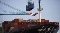
The domestic intermodal industry has long been plagued by an inability to accurately track and report, in a timely manner, the status of a container in transit. Historically, that’s put intermodal at a disadvantage compared with over-the-road trucking, in which GPS-enabled cargo and equipment-tracking sensors have been widely adopted for over-the-road trailers of all types.
Yet while intermodal may be playing catch-up in the real-time freight visibility race, the consensus among industry watchers is that the gap is closing — fast. You can thank the Internet of Things revolution and the emergence of “in the cloud” software and database platforms.
RELATED: Asset tracking spreads to intermodal chassis
Increasingly, providers of trailer-tracking systems, such as SkyBitz, Spireon, Truck-Lite, Phillips Industries and even Blackberry, are offering tracking devices for intermodal containers and chassis.
Functional scope and levels of market penetration vary. SkyBitz’s devices are deployed across thousands of containers with major fleets. Others, such as Spireon’s FleetLocate and Truck-Lite’s Road Ready systems, have a strong foothold on the chassis side. And Blackberry, with its Blackberry Radar device, is in active trials with Class I railroads, as well as container and chassis fleets.
Designed specifically for the rigors of intermodal operations, these asset-tracking devices capture and transmit various types of data while a container is in motion or at rest. They provide location within feet and typically can transmit every 10 seconds or once a day, depending on fleet preference. They issue alerts. And they’re coupled with cloud-based data management and analysis tools to consolidate, clarify and deliver a raft of accurate, real-time information.
Intermodal operators are leveraging this technology to be more proactive and make better, faster decisions to squeeze more utilization — and revenue — out of assets while improving driver satisfaction and retention.
At the same time, shipper customers also have better data to react to and manage disruptions faster and more effectively.
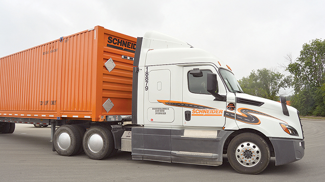
Two of the industry’s largest intermodal carriers, Hub Group and Schneider, were early adopters of GPS-enabled sensors on intermodal containers and have equipped virtually their entire fleets.

Spolum
In 2015, Hub Group started equipping each of its 37,000, 53-foot intermodal containers with tracking devices. Nearly fully deployed across the fleet, the sensors capture multiple data elements, including real-time location and door status, transmitting updates into the company’s transportation management system, where the data is visible to operations planners, drivers and customers, said Troy Spolum, Hub Group’s senior vice president of intermodal operations.
“It gives our customers visibility, increased capacity and security for their supply chain while improving our operations and maximizing our driver’s time,” Spolum said.
“The black hole of intermodal was always the street,” added David Marsh, Hub’s executive vice president of carrier procurement and marketing, who noted that today’s customers increasingly expect an Uber-like experience, with the ability to see the container’s location in real time and monitor its progress to its destination. “At any point in time, in our TMS, we [or the customer] can click on the box and it presents an aerial map showing where the box is,” he said.
Hub also employs software to “geofence” key locations in the container’s journey. These could be a customer warehouse or manufacturing site, rail ramps, rail yards, container staging areas, drayage lots — any mappable physical location along the container’s route that can be a customer-desired waypoint for updated information. When the GPS-enabled container enters or exits the geofenced location, it sends a time-stamped message into Hub’s TMS signaling that it has crossed the identified boundary.
All are important data points that can be configured and presented to the customer in a dashboard — and are invaluable to operations planners for reducing asset downtime, increasing utilization, improving customer service and driver retention.
Thanks to the tracking units, geofencing and other planning, analysis and data management tools, Hub Group has been able to add “more than a day of fleet use per container resulting in a larger effective fleet capacity,” Spolum said.
Marsh noted that the investment also has yielded “soft savings,” which are equally important.

Marsh
“We don’t have employees making phone calls to drivers to go check things, go look for a container,” he said. Precise container location and status “is now immediately available via the GPS. That’s a huge boost for drivers not wasting their time.”
Hub Group, based in Oak Brook, Ill., ranks No. 8 on the Transport Topics Top 100 list of the largest for-hire carriers in North America.
Schneider’s fleet of 20,000 intermodal containers is fully equipped with GPS-enabled sensors from SkyBitz, which provides an array of asset-tracking products and data services. Placed on the nose of a container, the unit’s battery is recharged via a small built-in solar panel. The units regularly record and transmit two primary pieces of information: the container’s location and whether it is loaded. Transmission interval typically is every 15 minutes but can be adjusted for specific reporting needs.
At any point in time, Schneider’s TMS is receiving data from some 100,000 digital devices spread across its network of drivers, trucks, trailers and containers, Chief Information Officer Shaleen Devgun said.
“It’s an ecosystem where the smart container is an essential part of the equation,” he said. “We are leveraging this to make near real-time decisions to run our network. To know where that container is and where it’s moving to is not only important to the customer, who wants to consume that information now, [it also allows us] to be proactive when there is a potential delay.”
Said Jim Filter, Schneider’s senior vice president and general manager of intermodal, “It creates the ability to improve velocity. The key thing is that we are sending a driver to a container that we know is empty.
“That really helps with driver satisfaction and retention when they don’t have to spend time driving around searching for a container. Plus, they are more productive.”
TT File Photo
Devgun said real-time container status information becomes that much more valuable when it’s married with other data resources, such as a driver’s mobile app, third parties and customer-specific product information.
“We bring it all together,” he said. “That’s really the power of our platform, the ability to gather and drive all that information to one place, and then present it, accurately and completely, to the customer.”
Like most intermodal operators, Schneider moves shipments with its own assets as well as those owned by third parties. About 30% of the industry is non-asset-based. A non-asset third party that is just “renting” a container typically won’t be making the investment in container asset-tag technology. That becomes a barrier to wider adoption.
Nevertheless, Devgun says that GPS-enabled intermodal container tracking has become table stakes with customers, with many increasingly calling for the capability as a requirement in requests for proposals.
Equally important is how the technology enables a better experience for drivers.
“Our two most important stakeholders are customers and drivers,” Filter said. “What’s great about this investment is that it provides a benefit for both.”
Schneider, based in Green Bay, Wisc., ranks No. 7 on the for-hire TT100.
Asset-tracking sensors for intermodal containers do have their unique challenges.
“It’s an extremely rugged environment,” SkyBitz President Henry Popplewell said. “The units must be designed to install simply and quickly, and fit within the corrugated ribs of the container.”
The units also need to adapt to different use conditions and report accurate information for those conditions.
“It could be moving, or sitting in a rail yard, at a port or a customer’s warehouse,” Popplewell said. “In each of those conditions, the device needs to behave differently.”
On rail, it might transmit location status once or twice a day. Stationary in a yard, the need might be only for “event management:” Did the condition of the container change, such as a door opening or closing, or repositioning in the yard?
“Yet if it’s on a chassis behind a truck, you want updates every 10, 15 minutes or sooner,” he said.
Popplewell said the four most critical data points for a tracking system to report are accurate, to-the-minute GPS-based location status, whether the container is loaded or empty, whether the door is open or closed, and for some products, the ability to send an alert if temperature and humidity fall outside of normal ranges.

Mead
What does the future hold?
“Today’s consumers … are getting more demanding,” said Gerry Mead, executive director of innovation for Phillips Industries.
“In the past, [intermodal] was not as efficient as putting freight on a truck,” he said. “Understanding their assets, and the best way to move them around, all with real-time data, will be the key to more efficient intermodal operations and faster movement of freight.”