


Seattle DOT Saves $500,000 With Road Work Planning App

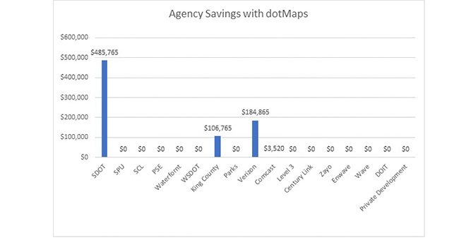
The Seattle Department of Transportation has saved more than $485,000 since August with an app that allows the city to coordinate with other entities on construction projects involving road work, according to Heather Marx, utility and project coordination manager at SDOT.
The app, called dotMaps, allows companies and public agencies to view one another’s planned projects to coordinate work and minimize waste, according to SADA Systems, the technology company that built the tool. SADA said in a Nov. 14 press release that the app is projected to save SDOT $7 million within the first year of use.
Marx told Transport Topics the tool offers an interactive map showing projects that require trenching, such as sewage, telecommunications and steam pipelines. One of the app’s side benefits is that all involved entities—government agencies, steam and energy companies, and telecom providers such as Verizon and Comcast—save money because they can share the cost of restoration.
Seattle Department of Transportation
“Ideally, it’s with the moderation of the DOT as oversight, but it’s massively efficient for companies to work either with one another or with the DOT itself,” Patrick Skoglund, practice director for Google Cloud and Maps for SADA Systems, said in an interview with TT.
“Without a tool like dotMaps, a city will do the work without really understanding what the utility companies are planning on doing and once the city repaves the street, they’ll put a moratorium on it, increase the cost of the permit and the utility company will go in, cut up the street and repave it. So you’ve just wasted taxpayer dollars,” he said.
SADA worked with the Seattle government for about five months before launching dotMaps in August, according to Skoglund. Marx said the Seattle Information Technology Department was instrumental in setting up the app.
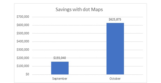
Organizations that have used dotMaps to coordinate projects since the app’s launch have saved about $800,000, SADA said. SDOT reported that dotMaps yielded $155,000 in savings in September and $625,000 in October for all participants.
Marx said the savings are based on final restoration costs, rather than temporary repairs. She explained that temporary restorations, usually consisting of cold mix asphalt, are quick and less expensive. She added that the purpose of adopting dotMaps was to avoid exacerbating congestion by minimizing the frequency of road closures.
“It was madness. We really needed a way to coordinate that stuff, both to protect the pavement as an asset and also to preserve access for the traveling public, which includes our friends in the freight industry,” Marx said. “We wanted to skinny up the time that there’s a hole in the street.”
Seattle Department of Transportation
Trucking is important to the Seattle area. According to the City of Seattle’s Freight Master Plan, 44% of the goods traveling to the city’s ports are transported by truck. Certain portions of state Route 99, a north-south corridor that bisects the city’s industrial district, see about 5,000 trucks a day. Marx said drayage operations also serve an important role as Seattle is a major port city.
Sheri Call, executive vice president of the Washington Trucking Associations, said Seattle’s savings are small compared with the funds that the city’s infrastructure requires. She said repairing the city’s potholes alone would cost more than $400,000.
“I would hope they would invest the savings into the roads, or ways to address congestion, which would help toward making Seattle more trucking-friendly,” Call said.
Besides allowing participants to view where and when one another’s construction projects will take place, dotMaps has a feature in which participating agencies can create detours and disseminate live traffic feeds. Skoglund said trucking companies can use of this feed, which is created for “special events,” such as if a company needs to move a train and shut down a road.
Marx confirmed that Seattle will start using the detour and feed-distribution tool once the city grows more comfortable with dotMaps.
“As we grow in using and learning more about the system, and as the system itself grows, we want to squeeze every bit of value out of it that we can. As time goes on, there will be more and more,” Marx said. “We are both blessed and cursed with narrow rights of way, so every inch is valuable, and we want to make sure that infrastructure projects can go ahead because that’s what helps the wheels spin, but we also want to make sure the business of the city and the business of the people who live here can continue to get done as well.”